Thirty-four million years ago, rivers carved valleys through a forested Antarctic landscape. Today, those same valleys sit frozen and perfectly preserved beneath more than 2 kilometers of ice — and the scientific community is only beginning to grasp what this means for our understanding of Earth’s climate history.
A hidden world sealed under the East Antarctic Ice Sheet
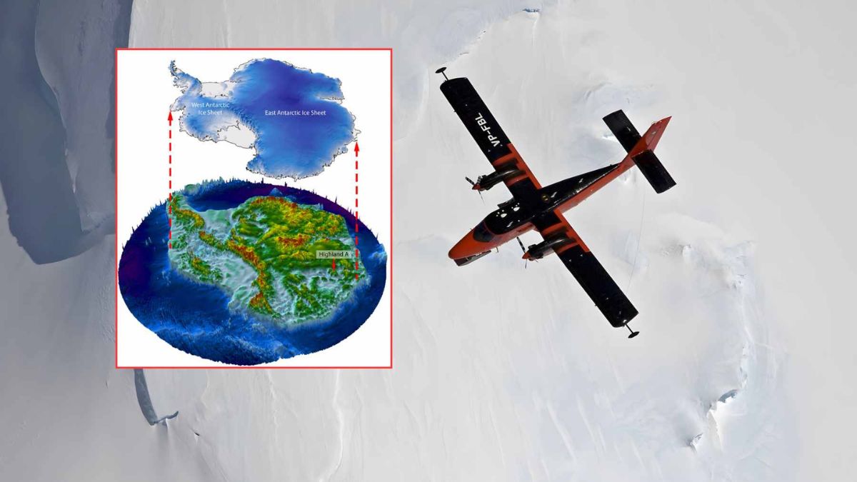
The East Antarctic Ice Sheet is no ordinary feature. It holds the largest single mass of ice on our planet, reaching thicknesses that exceed 2 kilometers in many places. What makes recent findings so striking is what lies directly beneath that crushing weight : a remarkably intact pre-glacial terrain of valleys, ridges, and coastal plains that has remained essentially untouched since the Eocene epoch ended around 34 million years ago.
Glaciologist Stewart Jamieson from Durham University led the team that identified this buried terrain. His group mapped three distinct elevated blocks of land, separated by deep troughs, sprawling across an area roughly equivalent to the state of Maryland. These aren’t the jagged, scraped surfaces typical of glacial erosion. They look like ancient river-carved valleys — because that is precisely what they are.
A complementary study published in Nature Geoscience, led by geophysicist Guy Paxman, pushed the analysis further. His team found that gently sloping or flat surfaces ring approximately 40 percent of the East Antarctic coastline. Once you account for the weight of the current ice pressing down on the bedrock, those surfaces align perfectly as a former coastal plain that once sloped gradually toward an ancient ocean. The picture that emerges is of a broad, low-lying landscape shaped by river systems operating between roughly 100 and 34 million years ago.
Why is the terrain so sharp after tens of millions of years ? The ice above has remained extremely cold and moved slowly enough to act as a protective blanket rather than an erosive force. The landscape beneath was sealed, not destroyed.
Radar pulses and satellite data : how scientists read the bedrock
Nobody drilled a hole and stumbled upon a buried forest. The detection methods are far more sophisticated — and frankly, impressive. The primary tool is radio echo sounding, where aircraft tow radar systems that fire electromagnetic pulses downward through the ice. Those pulses bounce off the bedrock and return to receivers above, building a detailed picture of what lies below without removing a single gram of ice.
Here is a simplified breakdown of the main detection techniques used :
- Airborne radio echo sounding — radar pulses sent through the ice sheet to map bedrock topography
- Satellite surface altimetry — missions like RADARSAT detect subtle variations in the ice surface caused by hidden ridges and valleys below
- Sediment core analysis — offshore marine cores provide biological and chemical proxies for past vegetation and climate
- Computer modeling — digital reconstructions simulate how the terrain would appear after removing the ice load
The next logical step, according to researchers involved in the Nature Geoscience work, is targeted drilling. Hot water drills and specialized coring systems have already accessed subglacial lakes and grounding zones elsewhere in Antarctica. Bringing up actual rock and sediment from beneath this specific terrain would transform what is currently an extraordinary interpretation into hard physical evidence.
From rainforests to ice : Antarctica’s dramatic climate reversal
The buried landscape only makes full sense when paired with what we know about Antarctica’s past climate. Marine sediment records from around the continent tell an extraordinary story. Before the ice sheet formed, coastal Antarctica supported temperate — possibly near-tropical — rainforests. Pollen grains, fern spores, and wax molecules from broadleaf trees and conifers have been extracted from cores drilled near the Antarctic Peninsula.
| Time period | Antarctic environment | Key evidence |
|---|---|---|
| ~100–50 million years ago | Tropical to warm temperate forests | Pollen, spores, fossil wood |
| ~50–34 million years ago | Cooling rainforest, river systems active | Plant wax molecules, sediment records |
| ~34 million years ago | Rapid glaciation, ice sheet formation | Oxygen isotope shifts, buried terrain preservation |
| Present | Ice-covered, terrain sealed below 2 km | Radar mapping, satellite data |
A 2014 study in Earth and Planetary Science Letters pinpointed this transition precisely : late Eocene forests cooled and dried sharply just before large-scale glaciation took hold. Falling atmospheric CO₂ combined with shifting ocean currents crossed a threshold that turned a green continent permanently white. The buried valleys are, in effect, the fossil record of that threshold.
Today’s closest geographic analogs for what ancient Antarctica probably looked like are southern Chile or New Zealand — dense forested hillsides, winding rivers, humid lowlands. Hard to picture standing on the current ice plateau, yet the geological record makes it undeniable.
Sea level projections depend on maps we are still drawing
This discovery carries urgent practical weight. The shape of the bedrock beneath an ice sheet controls how ice flows. Flat ancient plains slow ice movement, while deep troughs channel it rapidly toward the ocean. East Antarctica contains enough water, if fully melted, to raise global sea levels by more than 50 meters — a number that puts every coastal city on notice.
Knowing exactly where those ancient river plains and subglacial valleys sit helps climate modelers calculate sector-by-sector vulnerability far more accurately than before. The difference between a well-mapped and a poorly mapped subglacial terrain can mean projecting decades of margin in coastal planning decisions affecting cities like Miami, Rotterdam, and Mumbai. Insurance pricing, infrastructure investment horizons, and flood barrier design all feed from these projections. Better subglacial maps aren’t academic luxuries — they are tools cities will depend on.
